
The Via Consolare Project in Pompeii
|
|
||||||||
|
The Via Consolare Project in Pompeii
| ||||||||
| Home | Research | Internships | Team | Links | Contact | |||
| Summary | 2005/2006 | 2007 | 2008 | 2009 | 2010 | 2011 | 2012 | 2013 | 2014 | 2015 | 2016 | 2017 | 2018 | VCP 3D |
| 2019 |

Plan of the locations of AA007 and AA008 within Insula 7 6. 
Excavation underway in AA007 in 2013. 
3D point cloud of AA007 produced with structure from motion (SFM) technology. 
Fragments of plaster recovered from pits in AA008. 
3D mesh of amphora soak-away in AA008 produced with structure from motion (SFM) technology. 
Excavation underway in AA007. |
Field Season 2013 During the summer of 2013 with the kind permission of the Ministero per i Beni e le Attività Culturali: Soprintendenza Speciale per i Beni Archeologici di Napoli e Pompei and with great assistance from Prof.ssa Cinquantaquattro, Dott.ssa Stefani, Dott.ssa Pardi, and Assistente Sabini, members of the Via Consolare Project conducted archaeological investigations in Insula VII 6 as a part of our on-going research into the chronology, urban development, and utilization of the properties along the Via Consolare, the area of the Villa delle Colonne a mosaico, and especially Insula VII 6. Research undertaken this summer involved two trenches within the area of Insula VII 6. The first (AA007) was situated at the southern end of the peristyle of the Casa di Secundus Tyrannus Fortunatus, and the second, (AA008) was located on the southern side of the shop at doorway 16, against the northern wall of the so-called ‘Great Cistern.’ In tandem with stratigraphic excavation, artefacts and ecofacts recovered were catalogued and studied, while continued topographic survey was carried out on the streets around Insula VII 6. Structure from Motion (SfM) technology was employed in the recording of all excavated deposits, including root cavities, cisterns, and floor surfaces, which were recorded in high-resolution 3D scans. The main goals of this season’s archaeological research were the following: 1. Extension of the excavations from 2012 in the peristyle of the Casa di Secundus Tyrannus Fortunatus in order to uncover a greater extent of a boundary wall in opus africanum (type A) that was uncovered in 2012 that clearly once continued further to the east. Excavation of the foundation trench of this wall would provide an important ceramic and/or numismatic terminus post quem for this important masonry style, dated by Peterse to between c. 450-420 BC,1 but not yet investigated or dated by the excavations within Insula VII 6. 2. Recovery of any surviving traces of the garden of the Casa di Secundus Tyrannus Fortunatus in order to sample these deposits for archaeobotanical analysis. 3. Assessment of the state of preservation of AD 79 remains in north-east corner of the Insula; recording of all preserved remains; and commencement of stratigraphic investigations into early phases of utilization, structural alignments, and inhabitation in this quadrant of the insula. 4. Recovery of the builder’s trench for the so-called ‘Great Cistern’ on the eastern side of the block and provision of the first stratigraphically-derived date for this important structure. 5. Complete 3D recording of excavated deposits using Total Station Survey and open-source Structure from Motion (SfM) technologies to provide a complete, volumetric 3D record of the excavation. 6. Recording, processing, and analysis of small finds and ecofacts recovered from the current trenches in concert with excavation in order to provide immediate chronological feedback and to speed the process of publication. Practically all of these goals were achieved successfully during the summer of 2013. In AA007, a trench located in the peristyle of the Casa di Secundus Tyrannus Fortunatus, the full stratigraphic sequence of deposits from natural to final phase was recovered, despite the very difficult conditions caused by a bomb that hit the area in 1943. While as we noted in our 2012 publication in Fasti Online,2 and in our reports from previous years, in general the majority of the damage from bombing in Insula VII 6 appears to have been received by the walls, leaving the subsurface largely intact, the situation was found to be different in the open space of the peristyle where AA007 was excavated and damage from bombing here proved to be considerably more extensive. The damage encountered in AA007 appears to have been produced by a single bomb that managed to land in the north-east corner of the garden and penetrate the soil, creating a massive crater and sending shock waves through the surrounding soils that created radial fractures in nearby floors and preserved deposits. Both of these aspects of the record were clearly visible in our excavations in the area. In addition, in roughly the centre of the garden, two ancient pits that had been cut in preparation for subsequent construction activities in the mid-first century AD, had served to obliterate traces of the earlier opus africanum wall that we discovered in 2012. The fills of these pits, which produced considerable amounts of decorated wall-plaster that probably derives from the now-missing wall, nevertheless suggested the general location of at least a north-south plot division. Remains of the AD 79 structure were found to be more extensive, such that the remains of floors, brick columns, the stylobate, and peristyle drain mirroring those recovered on the west in 2012 were also discovered on the eastern side of the house and recorded in great detail. Similarly, the soils of the garden itself were found to be intact in the south-western corner of the garden, in much the same condition as was visible in Spano’s report on the insula in which a published photo shows the void left by a tree filled with lapilli.3 This year, the same voids, which had never been cast in plaster by Spano, were found sufficiently well-preserved and intact despite years of exposure, bombing, and reburial to permit the creation of a plaster cast in order to study the root system. Excavation around this cast will be undertaken in 2014. On the south-eastern side of AA007, the AD 79 lavapesto floor, a lead pipe that had brought water into the peristyle from the east and a large drain running down the corridor were all found to be well-preserved. The drain yet contained lapilli that had not been removed in the initial excavations. A very deep and narrow cistern was also found to be attached to this water system that similarly had not been excavated of its lapilli. Excavations in the shop on the northern side of the ‘Great Cistern,’ (AA008) produced considerable remains surviving from AD 79, including final-phase floors, traces of earlier phases of wall decoration, and cuts intended for wooden fixtures that appear to have been installed during the last years of the city. To the west of the shop floor, features recorded by the initial excavators as a room were found actually to consist of a raised platform built over a series of cisterns/cess-pits, and a soak-away under an opus signinum floor. This cistern/cesspit was found to preserve traces of its original vaulting, and contained a sloping fill of lapilli that had clearly entered via down-pipe located on the southern wall, plausibly for an upstairs toilet. Though excavations in this area have not yet been completed, it is clear that the remains of numerous features prior to the ‘Great Cistern’ and the current arrangement of walls have begun to appear in this quarter of the Insula, probably including at least one earlier phase of the cistern/cesspit. The construction of certain elements of these earlier features, in small, carefully-shaped blocks of sarno stone, mirror the earliest constructions found elsewhere in the block, particularly the walls in opus africanum (A). This is especially true of two rows of vossoirs in sarno stone, which were visible in the eastern wall of the cistern/cesspit. By far the most important feature recovered from AA008 however, was the broad, two-step cut for the creation of the ‘Great Cistern’ itself. The material from the fill of this cut will provide the first date for this important structure derived from excavation, and the fact that the cut was made through earlier shop floors that appear to have been the actual surfaces on which the activities of the shops took place will hopefully give considerable insight into the daily life of the area before this large infrastructural feature was added to Insula VII 6. The VCP has pioneered the use of open-source structure from motion (SfM) technologies for archaeological research during the last several years. In 2013 this work continued with the complete recording in sub-centimetric three-dimensional detail of all aspects of our excavation and research, including each stratigraphic unit, feature, wall, and pavement. Many of these have been processed in-field producing point clouds of many millions of points. Once meshed, these will be coordinated into a complete, spatially-referenced, three-dimensional model of the excavation, including all sub-surface deposits, features, and surfaces at an unprecedented level of detail. This work is combined with 3D topographic survey of each trench which serves to interconnect all 3D scanning from Structure from Motion with traditionally hand-drawn plans into a complete, geo-referenced record. |
|
Archaeological Area AA007
The 2013 season included the continuation of investigations into the arrangement and history of the Casa di Secundus Tyrannus Fortunatus, building on the findings from excavations in 2012. A large (11m by 5m) trench, occupying approximately the southern half of the garden space and extending to the southeast corner of the peristyle, was situated to be adjacent to the location our excavations in 2012 (AA006). Governing this placement was the hope that additional evidence of the continuation of the early opus africanum wall in AA006 extending at depth (Peterse’s type A) might be discovered with enough associated builders’ trench to be able to date the construction securely. In addition, it was hoped that further information about the exchange of property between the Casa di Cipius Pamphilus Felix and differing division of space in what would become the peristyle of the Casa di Secundus Tyrannus Fortunatus might be recovered by placing a trench in this location. Phase 1 – Natural Soils A rich brown soil, lacking entirely any anthropogenic finds was visible in the section of several large cuts, but particularly on the eastern side of the garden space. Generally 1.5m below the modern ground level, this stratum is thought to be a naturally-occurring deposition of soil prior to human intervention. Above this ‘natural’ layer was found a greyish-brown silt with coarse sand-sized inclusions that is regularly found topping this layer. This sequence of soils was also discovered in our excavations in AA001 and AA006 in previous years as well as in other areas of the city, most particularly in Insula VI 1, and the Casa degli Epigrammi Greci.4 Here, however, this dark silt-sand layer was found to have been disturbed by activity in later phases. It is hoped that this deposit may be identified precisely with one of the interplinian eruptions that may have been the cause for these deposits in Insula VII 6, and perhaps lend support to recent theories of the 5th c. gap in Pompeian occupation history.5 Unfortunately, due to later ancient activity in the area of the peristyle garden that removed much of this deposit, too little was uncovered to be of much use for developing a greater understanding of this deposit. However, it may be said that all remains of the earliest human interventions appear to have been built immediately atop this dark silt-sand, often seeming to use it as a bedding layer. Phase 2 – Earliest Activities The earliest human activity in the area of AA007 was evident only in the southeast corner of the garden, surviving at the edges of the later central garden space that generally had been subjected to later pit cuts. This activity was signalled by the presence of block of mortared stones shaped into a trapezoidal ‘burm’ or channel edge, at 36.9873 masl, the full original form of which is unclear. A surface of hard-packed earth abuts this feature, though again insufficient surface survives to be able to explain its intended use. Associated with this construction is a second mortar feature whose use is even more opaque, as a result of damage caused in the 1943 bombing. The remains of this feature are unlikely to be in its original orientation, as it seems to have slipped into a fissure caused by bomb shock waves. On the northern side, it was clearly poured around a post or some other cylindrical object, where the mortar preserved the form of the fitting. The surface and the mortar feature both terminate to the west at the same point, respecting what might be a cut through them, or what might have been the original terminus of a coordinated feature. This linearity between the two also mirrors the north/south alignment of cut that might have been for a wall fragment found slightly north of these features. Since the sequence has been churned by the bomb damage, the order in which these early features may have been created may be understood in two ways. The first way of interpreting these remains would suggest that the wall may have been the first feature present, continuing to the western side of the mortar ‘burm’ and surface. This wall would then have served as the western boundary to these features, which would in turn have been poured or built up against it. Alternatively, this wall may have cut the early features, as the cut through them aligns neatly with segments of a cut on the eastern side of the wall fragment. Regardless, the location of the wall as it was found is certainly not exactly where it stood originally, nor does it preserve the original associations of surrounding features, since it clearly been knocked into the fills of later pits in the area during later cutting activities. However, it should be noted that the alignment and location of the wall does correspond with the eastern tablinum wall of the Casa di Secundus Tyrannus Fortunatus, suggesting that if this wall is to be associated with this phase, certain features of the house’s layout may have rather early origins. The overall alignment of the cut is also appears to coordinate with the course of the Vicolo delle Terme, suggesting that even if the wall itself is no longer place, that it helps to preserve the rough location of a wall aligned with this street. The fragmentary survival of the evidence for the earliest activities in the area defies a single explanation and deciding between the several possible alternatives is not possible at this stage. Building on the findings from 2012, wherein it was thought that the area of AA007 might be a back garden for the earlier arrangement of the Casa di Pamphilus Felix, the presence of the mortar ‘burm’ and surface on the eastern side as the earliest feature suggests that the area was not open green space on that side, but likely had a few built features, that probably were on the other side of a boundary wall. While the activities in the later-phase garden truncated this evidence even further, future excavation in the southeast corner of the peristyle may enable greater clarification of these activities. Phase 3 – Opus signinum floors and lost architecture While it seems likely that a division already existed between the eastern and the western sides of AA007, it is clear that this was the case by the time of the creation of floors in the Casa di Cipius Pamphilus Felix, which excavations in 2012 placed at roughly the beginning of the 1st c. BCE. Three fragmentary portions of opus signinum floor were recovered in the northwest, southwest, and southeast corners of the trench, at a slightly different elevation from each other (NW – 36.9076 masl; SW – 37.0793 masl; SE – 37.3042 masl). This difference in elevation necessitates some means by which the discrepancy in level may be explained. The presence of a now lost wall or walls somewhere between these floors is one possible solution for the clear lack of continuity of more than 30cm between floor levels on the east and west. Such a wall dividing these floor levels would also have limited the eastern extent of the Casa di Cipius Pamphilus Felix. In 2012, the discovery of a opus signinum floor at depth in AA006 (36.9237 masl) demonstrated that the house extended further east than the current property divisions suggest, but how far east was unclear. The similarities in elevation and general location of the western opus signinum fragments in AA007 make it seem likely that these comprise elements of a single floor or group of related floors. Unfortunately, later activity in the garden space removed any evidence of details about such a division of space, whether a wall, a step, several walls, or some other unknown feature coordinating the surfaces. |

View of AA007 from the north and its position adjacent to AA006 from 2012 (in red). 
Early construction in the form of a mortar ‘burm’ of unclear use. 
Cut through early features (a). Wall fragment respecting a similar alignment (b). 
Alignment correspondence between early wall and tablinum wall. 
Three fragments of opus signinum (a, b, and c) in the extremes of the excavated area. |

Large pits cut through earlier activity and their building material fill (a). 

Two panels of polychrome plaster found as a component of the contents of the pit fills. 
Peristyle gutter. 
Cistern located in the southeast corner of the peristyle with cistern cap rotated to accommodate column placement. 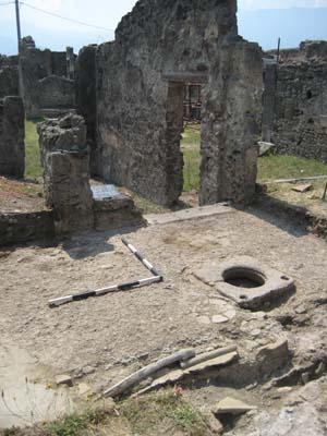
Black lava threshold matching the material of the cistern cap and black lavapesto flooring. 
The view toward the altar in the garden as it survives today. 
Addition of a lead pipe and large drain, covered by an earth surface, draining the peristyle down a corridor east towards the vicolo delle Terme. 
Clear evidence of the damage caused by the 1943 bomb drop, evident in the radial fissures through the area and undulation of the lavapesto floor to the east. |
Phase 4 –Incorporation into the Casa di Secundus Tyrannus Fortunatus, First Phase
The space of the peristyle was subsequently altered in order to create the present arrangement. This was likely coordinated with the changes surrounding the acquisition of Rooms α and β by the Casa di Secundus Tyrannus Fortunatus, which occurred some time after the beginning of the reign of Tiberius. Those alterations that were observed within the area of AA007 ultimately incorporated the spaces originally defined by all three opus signinum surfaces. If there had been walls dividing these spaces, it is clear that these were levelled and removed at this time to make space for the garden and peristyle. Significantly, this suggests that the creation of the peristyle involved the acquisition of spaces from several surrounding properties, including the Casa di Cipius Pamphilus Felix, but also areas that seem to have belonged originally to a separate property on the east. Indeed, the levels of the south-western opus signinum imply that not even the southern areas of the later peristyle had previously belonged to the Casa di Secundus Tyrannus Fortunatus. The most significant activity in this phase recovered from excavation was the cutting and filling of at least two large pits in sequence. Unfortunately, fissuring during the bombing of 1943 confused the edges between these pits sufficiently that the precise order of the cuts could no longer be determined, but it is quite clear that they were part of the same general phase of activity. Cut directly through the opus signinum floors of the previous phase, these pits encompassed the majority of the excavated area and served to remove any evidence of the structures that might have originally divided the space. Supporting the idea that there had been such a wall however, is the nature of the fills of these pits, which generally consisted of large-scale building material, robbed of any reusable stones, such that plaster, mortar and stucco predominated. Clearly the destruction of standing architecture, this may have included the wall mentioned in phase 2 as part of the fill. The very walls that once may have divided the space into smaller rooms with their various floors therefore seem to have become the fill of the pits that destroyed them. The original purpose was for the cutting of these pits seems likely to have been to gain access to unadulterated soils at depth, perhaps in order to obtain clean grit for use in new plasters and mortars for any new constructions in this phase. Such activity is understandable if large-scale reorganization and construction was intended to follow. The depth of these pits was not reached in our excavations because they were deeper than allowable under modern health and safety plan requirements. Within the fill of these pits was a high volume of polychrome decorated plaster. Though a common component of rubble dumps, these fragments were remarkable in that they were identifiably Third Style, preserved in high enough volume to be able to reconstruct a considerable amount of the original decorative scheme, which fell into several major panels. The largest number of fragments related to a panel with two rows of blue bands bordered by thin purple lines framing a white central panel. The upper portion of this area was capped by a stucco cornice at the ceiling. A second set of fragments attest to a series of black ground fields with tracery decoration and garlands, separated by a broad string course praedilla the secco details of which were sadly lost, over red panels with thin white borders. Divided into some three to five central panels, the specific details of the decoration could not be determined with the surviving portions but may be recoverable with further examination. However, it is likely that these areas had a black upper zone and red lower or middle zone. The orientation of the red and black panels could not be discerned from the material recovered, and their relationship with the blue and white panels remains unclear. Surviving fine decoration included white garlands and attenuated candelabra on a black background, central figural details such as still-life olives or garden scenes, and even the traces of one foot and leg from a floating figure. Further analysis of these details may yet reveal more of the overall design, which on the basis of the level of detail preserved even having lost further details in secco, and overall lack of perspective, the emphasis on broad flat panels, and the overall palette, appears to belong to the Third Style, probably during the early years of 1st c. AD. The evidence generally offered by the painted plaster in the pits parallels that from the preserved walls of 2012 and emphasizes the interrelated nature of the changes prior to the creation of the peristyle. Wall plaster from nearby walls that had been put out of use were knocked off of these walls and deposited near to the where they had originally stood. Stones from the walls, likely reused in later incertum constructions, were largely removed from the mixture, leaving mortar, opus signinum fragments, wall plaster, etc. seemingly not useful for future construction. The presence of Third Style wall painting fragments in a rubble deposition preceding the construction of the peristyle of the Casa di Secundus Tyrannus Fortunatus accords reasonably well with the earliest terminus post quem possible from the related material analysed in 2012 as well as the interpretation of the changing fortunes of the adjacent properties, but may serve to push the dating of the change to a slightly later date (by perhaps a generation). As understood from pottery dating in 2012, the transformation of the Casa di Tyrannus Secundus occurred after the beginning of the reign of Tiberius. Indeed, the Third Style wall paintings, which can scarcely belong to the late period of the Third Style, having been destroyed and deposited into these pits suggest a date somewhere between the final years of the 1st c. BC and the reign of Claudius. Following the cutting and filling of these pits, the peristyle of the Casa di Secundus Tyrannus Fortunatus was constructed, coordinating with Phase 6a of AA006. At this moment, the peristyle gutter running around the inside boundary of the central garden space was constructed in mortar and stone, creating the canonical form. At the same time, a cistern was constructed in the southeast corner of the peristyle using several building techniques. The deepest portions of the build lack any constructed walls. Instead, the shaft was cut directly into the soil and covered in a waterproof plaster. Approximately 90 centimetres below the cistern cap, this construction method switched to a stone and mortar construction. This construction must have been built at the same time as the peristyle gutter, as the gutter’s construction incorporates an inlet to the cistern on the cistern’s northern side built in the same mortar and stone materials. This would have allowed for water run-off from the colonnade to feed into the cistern. Approximately 20 centimetres from the cistern cap, a third construction technique was utilized. This took the form of a roughly square red ceramic opus signinum, arranged on the alignment of the room as a whole. However, the placement of brick columns for the colonnade seems to have gotten in the way of the final cistern arrangement. The black lava cistern cap, set within the opus signinum upper cistern construction, was rotated counter clockwise to enable the placement of the most south-eastern column of the colonnade. After the placement of the columns and the cistern cap, as well as the plastering of the eastern wall of the room, the final black lavapesto floor with inset tesserae in lines was poured, covering the build of the gutter and the area of the colonnaded walking space in one continuous surface. This floor was also poured up to and around the columns of the colonnade, which were then plastered. This order of construction is different to the order of construction on the western side of the peristyle as found in AA006. On the western side, the columns were constructed, plastered, and then the black lavapesto was poured up against this plaster. Such a discrepancy may suggest simply the manner in which the peristyle was constructed and indicate the phases of building within a single event, or might reveal changes to the arrangement that will become clear with further investigation next year. The lavapesto was also poured up to a black lava threshold that formed the southern boundary of the southeast corner of the room. That this threshold matched the material of the cistern cap, as well as the pivot stones of the doorway to room on the west side of the peristyle demonstrates a stylistic coordination of materials in the decoration of the house. During this phase, the garden space must have been planted. As shown in photos from the 1910 excavations under Spano6 , evidence of root cavities was found along the western extent of the central garden, as well as the construction of a small altar or shrine. Only the lowest footings its construction were recovered intact in 2013, preserving a rectangular and highly fragmentary base constructed in earth and lime mortar with a fragment of plaster adhered to the northern face. The surviving evidence for the plants themselves in the area was more extensive. As shown in the same 1910 photo, and discussed at length in the text of the NdS, a substantial tree was thought to have been present just south of the altar. In the adjoining photo, a heap of lapilli is the only evidence for this assertion, and our assumption was that a root cast must have been made following excavation. Instead, it was discovered that after the discovery of the cavity, no further excavation had been undertaken and no cast was made. Our interventions found the cavity still filled with undisturbed lapilli. With the kind help of Assistente Tecnico Sabini, Archetecta Pardi, Dottore De Carolis, and with specific permission from the Soprintendenza Archeologica di Pompei, we were successful in creating a cast of the cavity and will undertake further study of this important evidence in future seasons. Phase 5 – Later Changes Very few changes seem to have been made to the peristyle in the Casa di Secundus Tyrannus Fortunatus during the subsequent years. These involved the addition of a lead pipe that must have brought water into the peristyle for a fountain as well as the cutting of a drain on the western side of the room draining water from a channel cut in the western wall as identified in 2012. Presumably, this created an abundance of additional water that necessitated the construction of a new outflow from the area. A large, 15 cm by 20 cm drain cut through the south-eastern corner of the peristyle gutter to enable this overabundance to be funnelled to the east and down a corridor out to the vicolo delle Terme. This drain channel was lined in waterproof plaster and capped with tiles before the lead pipe was laid across its length. A packed earth floor covered both, spread out over the top of the peristyle colonnade’s lavapesto to even out the cut made through it. This appears to have served as the working floor for the corridor that connected the peristyle to service rooms and the shop at doorway 19. From excavations in 2012 (AA006), it is known that the rooms on the western side received considerable changes in the period between the earthquake(s) of AD 62 and the eruption. It is therefore possible that these the alterations to the water system, involving the lead in-pipe and new down-pipe arrangement may have also occurred during this time. It seems unlikely that of these features was actually completed at the time of the eruption. Phase 6 - Modern Evidence of activity in the area in the modern period was extensive and largely destructive in nature. After the clearance of the eruption debris by Spano, as mentioned above, the area seems to have stood as excavated and to have required only mild conservation efforts. In 1943, as is well known, a number of bombs heavily damaged Insula VII 6. The damage was particularly heavy in the area of AA007. One bomb seems to have penetrated to the ground just north of the northern boundary of the AA, causing a considerable damage to the area. A large crater was formed, the southern edge of which was visible within the northern portion of AA007. However, the blast had more insidious effects within the excavated area. It seems that the physics of the explosion caused a shock-wave that moved laterally through surrounding soils, effecting an upheaval of the stratified remains, disarticulating them along a roughly circular radial fissure, and then causing them to settle back into a slumped depression. The resulting presentation of the stratigraphy proved maddening at times – deposits were mixed at the edges of this radial fissure, and few level surfaces were preserved, slumped down into the depression of the crater. Most evocative of this activity was the preservation of the eastern extent of the colonnade walkway, where the lavapesto undulates, broken at the southern end through the near midpoint of the drain addition presumably because this was a weak point in the construction. The fissure also obscured associations of the earliest building activities, the true nature of the wall within the trench and whether it was in situ, or was simply part of the fill of one of the large pits. Curiously, although the blast seems to have destroyed the altar, the root cavity just to its south survived with no appreciable damage. Similarly, the stylobate supporting the western range of columns for the colonnade seems to have quelled the damage to its west, creating a higher degree of preservation as found in AA006. Overall, despite the considerable damage caused by the bombing of the area of AA007, a great deal of vital information was found to be preserved. Excavation of this area enabled us to understand the formation processes of those elements of the stratigraphy not destroyed by a bomb, and salvage as much as possible from such a location. Additionally, having found only the southern edge of the bomb crater, it is clear that little survives of the northern portion of the garden space which will not receive further sub-surface investigation. |
|
Archaeological Area AA008 The choice of location for AA008 was determined by our six preceding years of study in insula VII 6 and our final architectural analysis of the standing remains. In pursuit of our interest concerning the development of Insula VII 6, the impact of the establishment of the Roman colonia, and the process of appropriation of private property for municipal buildings, a trench measuring approximately nine metres by three metres, was laid out at doorway 16, abutting the northern wall of the ‘Great Cistern’ to the west of the Forum Baths. The specific goals of this excavation area were to recover material from the construction trench of the ‘Great Cistern’ to the south and to evaluate how the construction of this element of municipal infrastructure changed the layout of this shop in particular, and the south-eastern and north-eastern ends of the insula more generally. We also sought to clarify the precise layout and function of the ‘shop’ itself, which has generally been without more precise designation. AA008 extended from the threshold of doorway 16 at a width of three metres and length of six metres, extending approximately half of the full width of the shop. Phase 1 - Natural Soils The same rich brown, silty soil found at some depth (approximately 2m) in the centre of the Insula was encountered in AA008 at the relatively shallow depth of approximately 75 cm underlying all cultural material and strata in two areas of the front end of AA008 (Room 65). In both instances it was topped by a stratum of greyish-brown silt with coarse-sand sized inclusions that has been documented in our excavations of AA001, AA006, and AA007, as well as other areas of the city (cf. AA007 supra). These natural soil deposits were uncovered directly below strata with intensive anthropogenic use. The first of these deposits had been cut by the construction trench for the northern wall of the large cistern (VII 6, 17-18), atop of which only a very thin layer of the greyish brown sand was preserved. The second instance of these deposits was discovered below a fragmentary opus signinum floor and its relatively thick sub-floor. Both instances of these deposits had clearly and deliberately been modified by later construction activity, though in different chronological phases. An insufficient amount of these early deposits was recovered to allow for broader analysis of their function, but given the generally broad extent across our excavations in Insula VII 6, and knowledge of similar deposits from around the city, it seems likely that these deposits relate small-scale volcanic activities that may have taken place during Pompeii’s 5th c. BCE 'gap' in archaeological evidence. It is clear, however, that these natural soils form the base layer for the earliest human intervention and building activities in this area, meaning that much of the area of Insula VII 6 appears to have been unoccupied until at least the subsequent period. Phase 2 - Earliest Activities The earliest phase evident in AA008 is characterised by a north-south running wall located in the centre of the excavation area. This wall is composed of sarno stone that has been finished into small rectangular blocks of roughly similar size. These blocks are laid out in horizontal courses, the eastern face of which is only partially visible, where is was obscured by a mortar facing, while the western face remains covered by an as yet unexcavated sloping eruption deposit with small, dense lapilli inclusions. The top of this wall was constructed with two embedded arches, one on the eastern and western face, respectively. These arches are composed of worked sarno stone voussoirs, while the space beneath the arches are filled with irregularly shaped sarno stone impressed in what appears to be an opus incertum build. This early sarno stone wall was not excavated at a depth greater than 1.00m nor was its foundation trench uncovered. Thus, the precise nature and function of this wall as well as these arches is currently somewhat obscure. Presently it is believed that the wall was cut and constructed into the natural soil. The wall itself may form part of a shop or row house, the type of which are present in the southeastern corner of Insula VII 6. The arches appear to be slightly decorative, but could have certainly had a structural function as supporting elements of this wall. It is also possible that these voussoirs once performed a function pertaining to passage through the space below this pair of arches. Further investigation of the extent of this wall and clarification of its original and evolving functions will form one of our research goals for the 2014 season. Phase 3 - Northern Extension of Early Sarno Wall and Initial Construction of a Back Room Phase 3 is represented by the northern extension of the early sarno stone wall and the articulation of a back room in this shop by the construction of an east-west running wall. The construction of this wall and its foundation cut into the pre-existing natural soils that were detailed in Phase 1 above. This cut was very steep, nearly vertical, and left only a very short and narrow construction trench, approximately 20 centimetres in length by 5 centimetres in width, that was visible adjacent to the eastern face and southern end of this later wall. The narrow nature of this construction cut led to the conclusion that this wall and its foundation were built directly against the natural soils and from the western face, where this addition is visible at a greater depth. As a result of this action, the sarno stone wall of the previous phase was extended to the north by a wall that abuts its northern end and face. This wall displays mixed construction techniques. The base that was exposed by excavation consists of regularly-shaped, rectangular sarno stone blocks that are laid in horizontal courses. Above this is an opus testaceum build that continues to the preserved height of the wall. Despite the different building materials and techniques, this wall represents one phase and build, given the similar colour, consistency, and compositions of the mortars. The lower section of this wall may form part of the foundations of this wall, which are only visible as a mortar base and plinth on the eastern face of this wall. Both builds, furthermore, are keyed into a second wall that continues in a western return, running parallel to the northern extent of AA008. This east-west wall continues for a distance of approximately 4.00m. Its construction is significant, as it forms the earliest articulation of architectural space in the back of this shop. The precise nature of this early room, however, remains unknown. Excavation in this back area of the shop did not reach a great depth. Further investigation of the earlier phases of this room will form a focus in the 2014 field season. Immediately following the construction of this northern extension wall, a opus signinum surface with a deep subfloor was constructed, extending outward from its eastern face. At the time of its discovery, this opus signinum floor was preserved in small sections; a few were compact and resembled the original state of the floor, but the majority were simply degraded fragments, particularly near the wall with brick and tile facing. A layer of white, undecorated plaster was subsequently applied to the eastern faces of both the early sarno stone wall and the brick and tile extension, ending directly above the opus signinum floor. This wall, floor, and plaster combination provide a clearer picture of the layout of this space during this phase, although the function of these spaces remains unknown. The suggestion that this space formed part of a shop is a viable and logical possibility. Phase 4 - Working Surface and Possible Activity in the Back of the Shop Phase 4 was a short and intervening phase that pertained primarily to the use of the front end of the shop. It is characterized by the accumulation of a hard-packed, earthen surface that was approximately 4-6 centimetres thick and displayed frequent thin inclusions of lime. This accumulated atop roughly half of the opus signinum floor that was discovered in the small sondage in the centre of AA008. It is believed to have extended to doorway 16, as is suggested by its presence at the base of later narrow cuts (cf. infra) in this eastern half of the shop. The survival of a well-preserved lavapesto floor with marble inlay prohibited the complete exposure of this earthen surface. This highly laminate surface formed part of a use-floor that displayed repeated activity and slight build up of debris over time. It covered and filled many areas of the underlying Phase 3 opus signinum floor that had been destroyed or were otherwise missing. When this earthen surface was removed and examined for ecofactual material, it was discovered that it was composed of a very dense concentration of crushed pottery and small pottery fragments. It appears that this floor accumulated both as a temporary patching for the now degraded and fragmentary opus signinum floor underneath, but also as a result of activity that involved considerable foot traffic. This may be related to the masonry structure that was found in the rear of the shop, at the western limit of AA008. Excavation of the area revealed two short, parallel walls that are oriented north-south. The eastern wall was composed of large sarno blocks and some small black lava stones that were mortared together, while the western wall is composed of two very large black lava blocks and a miscellany of other materials, including brick, sarno, and large fragments of waterproof plaster, also bonded by mortar. The initial interpretation of this structure is that it may have been a drain, though its full extent was not able to be determined in our excavations during the 2013 season, and its fill did not tend to support such a conclusion. The presence of a drain in this back area fits well with stronger evidence of later water and/or waste storage in the western half of this shop that was found and is detailed in Phases 7b, 8, and 9a. While the correlation between the earthen floor in the eastern half of AA008 and the drain in the western half cannot be confirmed at this time, the construction and use of this drain does appear to constitute one of the earliest activities and constructions in the western half of AA008. Phase 5 - Remodelling for Water or Waste Storage Phase 5 involved remodelling of both the central and western areas of AA008 and the shop itself. In this phase, the eastern-most section of the hard-packed earthen surface from Phase 4 was cut away and removed by a north-south oriented cut that also sloped gently downward, removing material directly above the opus signinum floor of Phase 3. Two steps were constructed in the area where the earthen surface was removed. The first, in its preserved state, was constructed of a large, irregularly shaped black lava stone that was mortared together with smaller, irregularly shaped cruma and sarno stones. This measured 74 cm in length by 41 cm in width and was preserved at a height of 31 cm. The second step, which abutted the eastern, plastered face of the Phase 2 sarno wall, was constructed entirely of fragmented bricks and tiles. This step measured 83 cm in length by 46 cm in width and was preserved at a height of 24 cm. Both of these steps use the same light yellowish brown mortar and, despite their varying construction materials, appear to have been constructed in one action against the early sarno wall. These steps roughly match the height of this Phase 2 sarno wall, suggesting that they functioned to provide access to a raised floor level in the rear area of the shop. This raised level is believed to be the first phase of a cistern or a cesspit in the rear of the shop, an area that was clearly functioning as a cesspit by Phase 8 (cf. infra). This structure is best preserved in its final phase (Phase 9a), but can be described as a deep, subterranean chamber, confined by the walls from Phase 2 and Phase 3, as well an interior, now relatively damaged, rubble-based wall built approximately 1.20m west of these earlier walls (an later covered by a mortar vault in Phase 9a). Evidence of this first phase of water or waste storage is ephemeral at this point in our investigations, but should be clarified by further excavation at depth in the western end of AA008 in future research seasons. It is evident that this area was functioning in this capacity before the western extension of the northern wall of the ‘Great Cistern’ was constructed in Phase 6, as this wall was built directly over and on top of the top surface of a pre-existing cistern or a cesspit. Such a structure would have also required the existence of steps in order to reach the elevated platform which had been built around the cistern or a cesspit. Hence, the construction of the two steps against the central, early sarno wall for access to a raised back room of the shop and evidence of the existence of a cesspit or cistern prior to that present in the final phase have led us to suggest that these two events occurred in roughly the same chronological phase. Further study may serve to refine this chronology. Phase 6 - Construction of the ‘Great Cistern’ Phase 6 marks a dramatic change in the layout of Insula VII 6: the construction of the northern wall of the “Great Cistern.” In the process of this building activity, a construction trench was cut into the pre-existing levels, truncating several features of earlier phases in the southern area of AA008. This cut was recovered against the northern wall of the Great Cistern. The top of the two-step cut was discovered at a relatively shallow depth, approximate 45cm from the modern ground level. The length of this construction trench measured 3.60m in length by 0.80m in width; however, only a section, 1.40m by 0.80m in size, was fully excavated. This cut truncated the southern edges of the steps constructed from Phase 5 as well as the packed earth surface from Phase 4. Initially vertical, the cut removed part of the natural soils detailed in Phase 1 then sloped down and to the south, leaving a step of the natural soil deposit and ending at a depth of approximately 80 cm, meeting the top section of the foundation of the Great Cistern wall. Both the top section of the foundation wall and the base of the upper wall were revealed by the excavation of this construction trench. Moreover, the impressions of the wooden shuttering used during the construction of the Great Cistern’s northern wall were visible in the mortar facing both the broad foundation and the upper section of the wall. Notably, the construction of the northern wall of the Great Cistern did not destroy or truncate all of the earlier structures in this shop. While the cut for its construction truncated portions of the Phase 4 packed earth surface and Phase 5 steps, both the foundation and the above ground wall respected the early sarno wall from Phase 2. While it is not entirely clear why this structure was left intact, it may relate to its function at the time, perhaps as part of a cistern or a cesspit and the related difficulties associated with its removal. This reason for this action forms part of our ongoing research interest in this area of VII 6 and will be pursued in subsequent years. For a foundation trench, this was a relatively shallow depth, considering that the interior of the Great Cistern reaches a depth of nearly six metres from the modern ground level. It is therefore clear that the majority of the foundation for the Great Cistern was built from the interior of the very deep cut itself, which must butt against the natural soil and cut to the underlying lava plateau on which Pompeii is built. The overlying, above-ground wall was then built from the outside using this construction trench as a base. The composition of the foundation is somewhat obscured by the wall's mortar facing, but materials such as sarno stone, cruma, lava, and grey tuff were bonded with a pale brown mortar. The composition of the overlying main wall of the Great Cistern is similar. It incorporates roughly shaped sarno, lava, grey and yellow tuff, as well as cruma in an opus incertum build that is mortared together with a similar pale brown mortar and quoined into a brick corner in the northeast. This construction trench was subsequently filled in with rubble and coarse building materials, including sarno and cruma stones, brick and tile, and a dense concentration of mortar and finished plaster. Finds from these fill deposits included animal bone, glass, and iron, as well as pottery, including substantial fragments of terra sigillata, providing at least a general terminus post quem of the mid 1st c. BC, at least a little later than the date typically assigned to the Forum Baths. It is very likely however, that further analysis of the finds from this trench will make this date even later, as might be suggested by its overall construction materials. |

Natural soils deposit exposed in construction trench of Great Cistern. 
Natural soils deposit below opus signinum floor and subfloor. 
Eastern face of early sarno stone wall with voussoirs. 
Northern opus testaceum extension wall 
Early opus signinum floor and accompanying undecorated wall plaster. 
Hard-packed earthen surface and use floor in the front half of the shop. 
Drain in western half of AA008. 
Two steps leading up to the raised floor level in the back of the shop. 
Top of cut and rubble fill of the construction trench of the Great Cistern. 
Foundations and base of the above ground northern wall of the Great Cistern.. |

Lavapesto floor with marble inlay in front room of shop. 
L-shaped extension wall abutting the Great Cistern and creating the back room of the shop with (modern conserved) downpipe. 
Early opus signinum floor and channel accompanying the construction of the rear wall of the shop. 
Amphora soak-away below lavapesto floor in rear room of shop. 
Lavapesto floor over amphora conduit. 
Vaulted mortar cap of the final-phase cesspit and western area. 
Fragmentary mortar surface above Phase 8 lavapesto floor in rear of shop. 
Cuts in lavapesto floor in front half of shop for the installation of a cabinet or cupboard. 
Wall scars in the northern wall of the Great Cistern produced by the installation of cabinet or cupboard. |
Phase 7a - Decoration of the front of the shop
The activities of Phase 7 are likely to have taken place directly after or in concert with the creation of the ‘Great Cistern’ itself. They involve the creation of the final versions of the front rooms, which remained largely intact in the following periods, only experiencing mild alterations. The western raised area however, experienced considerable change in the following periods. Following the creation of the 'Great Cistern,' the walls were plastered with a pink or light red plaster which was found to extend across the north face of the Great Cistern wall and the brick/tile quoins on the eastern end of the trench. After this was completed, a subfloor and overlying lavapesto floor with large pieces of marble inlay was installed against the plastered Great Cistern wall. The arrangement of these marble fragments appears to place focus upon the northern side of the eastern doorway, perhaps suggesting that the southern side was normally occluded by a counter or table. If so, this furniture must have been in temporary ephemeral materials which have left no trace in the archaeological record. Phase 7b - Remodel of the Rear of the Shop Changes in Phase 7b further defined the space of the rear of the shop and the south-western extent of AA008. An opus incertum wall composed of lava, sarno, and cruma was built, abutting the western end of the 'Great Cistern' wall. This wall extended to the west and ended only after a long northern return, forming an L-shape. This construction closed off the southern and western end of this shop, creating a separate room in conjunction with the east-west wall constructed in Phase 3. Only a small section of the foundations of this wall were uncovered, on the eastern face of the northern wall. These foundations measure approximately 1.00m in length by 0.006m in width; however, no clear foundation trench was recovered. As the field season ended shortly after the discovery of these foundations, further investigation was not possible in 2013. The east-west leg of this wall was built directly atop a pre-existing water or waste storage structure, which runs underneath the eastern end of the wall. A downpipe was also built into this wall, directly above the top of this storage structure. Both of these pieces of evidence confirm the presence of a structure for water or waste storage, though the shape of the surviving downpipe, which matches Hobson’s discussion of upstairs toilets, might lend weight to the argument for waste storage. The earliest surface discovered that can be associated with this new wall is a relatively thick and compact opus signinum floor that is only preserved in the south-western corner, abutting the L-shaped wall. This floor preserves the remains of a lateral channel at its northernmost extent, the function of which is presently unclear. This will remain unknown until the overlying deposits can be removed and the full extent and appearance of this opus signinum floor can be examined. Phase 8 - Drainage and Raised Lavapesto Floor in Rear of Shop Phase 8 witnessed an intensification of activity in the rear room of the shop and confirmation that the space was utilized for waste storage during this phase. This phase consists of a dense and thick rubble subfloor that was mortared into the surface below. Within this rubble deposit was a nearly complete amphora, positioned on its side and broken open at both ends, that once acted to channel waste water from a hole in the overlying floor surface into the open chamber (subsequently covered by a mortared vaulted top in Phase 9a) of the semi-subterranean storage structure directly to the east. This amphora construction and the down-pipe in the adjacent wall, must have been conduits for waste into a cesspit, not channels for the collection and storage of clean water. This amphora and the surrounding rubble deposit also form the thick subfloor for a compact lavapesto floor that was poured directly on top. This lavapesto floor was poured directly against the L-shaped opus incertum wall constructed in Phase 7b and covers the early opus signinum floor, also constructed in Phase 7b, marking its disuse. This lavapesto floor was only partially preserved when it was discovered during excavation and was confined to the south-western corner of Phase 7b wall. The northern extent appears to have been removed by a cut and human intervention, possibly at the time when the final phase of the cesspit and the final surface were installed in this back area (Phase 9a). Furthermore, this floor was detached from parts of this wall and sloped downward from the north to the south, presumably as a result of the impact of extensive bombing in the area in 1943, in which it is clear that the northern wall of the shop was hit by a bomb and destroyed. Given its fragmentary state, we cannot confirm that this floor once extended over the cesspit in the east, but it is extremely likely. After this lavapesto floor had been poured, both walls of the L-shaped incertum back room were plastered with an undecorated white plaster, the few and small remains of which are visible overlying the preserved sections of the lavapesto floor. Phase 9a - Final Phase Cesspit and Surface in Back of Shop Phase 9 represents the final phase of ancient activity in the rear room of the shop, the western half of AA008. This phase is represented by three actions. First, the cesspit in the front area of the shop's back room received a vaulted mortar cap. The preserved remains of this top surface were mortared on top of the Phase 2 sarno wall and arches across the void below until it rests atop of the lavapesto floor from Phase 8. This mortared vault also rests upon a roughly constructed wall visible underneath this arch, which forms the eastern wall of the space within the cesspit. This mortar capping is composed of a mixture of sarno, cruma, lava, grey tuff, and brick that are mortared together by a light brownish-grey mortar. A narrow, but lengthy section of this same mortar capping is preserved abutting the southern face of the east-west leg of the wall constructed during Phase 3 in the initial definition of the raised platform, though it lacks the vaulted character of the preserved top in the centre of AA008. The presence of this mortar capping along this Phase 3 wall and its extension up to the L-shaped wall constructed in Phase 7b suggest that this capping once extended across the full space of this back room. Second, this final mortar capping appears to have covered the area exposed by the cut and destruction of Phase 8 lavapesto referred to above. It may have also been constructed in conjunction with a very fragmentary mortar surface that was found in two small and isolated locations. Each of these instances was directly above Phase 8 lavapesto floor and was constructed atop a thin preparation layer that consisted entirely of painted plaster, both monochrome and polychrome. This surface was found abutting the northern face of the Phase 7b opus incertum wall. While there is no physical connection between this final mortar surface and the mortar capping of the cesspit, the fact that they both overlie the lavapesto from Phase 8 confirm their position in a later phase and implies contemporaneity. Further refinement of this sequence, is not possible at this time. An application of white, undecorated plaster was the third and final action of this ultimate phase in the western half of AA008 and the back of the shop. The only evidence of this plaster decoration was a small fragment that remains on the southern face of the wall from Phase 3 (which defined the northern edge of the western raised platform), but is clearly applied atop the western extent of the mortar topping of the cesspit. Our understanding of the area between the cesspit and the exposed remains of the drain from Phase 4 as well as the drain itself is still incomplete. These areas will form a primary focus of our investigations during the 2014 field season. Phase 9b - Final Changes in the Front of the Shop A few minor changes characterize Phase 9b in the front of the shop in VII 6, 16, the eastern half of AA008. These changes involve the installation of an apparatus or piece of furniture against the north face of the 'Great Cistern' and probably the insertion of lava stone thresholds at the shop doors. A jagged L-shaped cut was created in the north-eastern brick/tile corner of the northern wall of the Great Cistern for the installation of two black lava threshold stones. Modern holes in the floor designed to hold the original fencing have obscured the original cut in the floor, but enough survives in order to suggest that these changes occurred at about this time. Probably at the same moment, two north-south cuts (approximately 1.40m long and 0.30m wide) were made into the lavapesto floor from Phase 7b, each with a correlating beam hole in the Great Cistern wall, and one long east-west cut (2.80m long and 0.30m wide) are visible. These cuts removed just the surface of the lavapesto floor in this area exposing the subfloor and leaving an isolated rectangular section of lavapesto floor against the north wall of the 'Great Cistern.' During excavation of the modern level within these cuts, numerous large iron nails were recovered along the same alignment, which are probably components of the feature missed by initial excavators. In addition, these cuts are linked to accompanying vertical wall scars also visible in the north face of the Great Cistern wall. We suggest that these cuts and wall scars were made by the installation of a storage apparatus, either a cabinet or cupboard, in the shop. The remains of this apparatus no longer exist, since they must have been organic. Initial excavations within the shop occurred prior to widespread casting of furniture features, and so any voids left in the lapilli by the decaying features must have been lost. The recovery of the numerous iron nails along these cuts however, provides evidence of the existence of some form of furniture, likely a cupboard or cabinet. These cuts and the installation of this cabinet constituted the final phase of the front end of this shop before it was buried by the eruption in 79 AD. Phase 10 - Eruption and Destruction The cesspit in the centre of AA008 preserves material from the eruption of Vesuvius in 79 AD. Excavation inside the cesspit revealed a substantial deposit of grey soil and a dense concentration of lapilli. This deposit must have accumulated during the course of the eruption, either through the conduits that led into the cesspit or after a collapse had exposed the interior of the cesspit. This deposit was not excavated in 2013, but was preserved for excavation during the 2014 field season which will clarify our understanding the size, extent, function, and chronological phasing of the cesspit. Phase 11 - Modern The area covered by AA008 was significantly impacted by modern intervention and events. Following the removal of the eruption debris, the area was bombed in 1943, with one impact site immediately to the north. The blast destroyed walls in close proximity and the impact disturbed the northernmost wall in AA008, causing it to bow outwards to the south. In addition, the western half of the trench, particularly the area in and surrounding the cesspit, appears to have experienced several instances of collapse, but also became the site for the dumping of modern waste. These episodes of collapse resulted in extensive intrusion of modern material, particularly food waste and beverage containers, into what were once ancient rubble deposits. Interpretations The stratigraphic data recovered from our excavations in AA008 have significantly enhanced our understanding of the eastern side of insula VII 6. This area illustrates an important sequence of small-scale events regarding the earliest activity in this area as well as the creation, development, and evolving usage of the shop at doorway 16. Equally important, we have begun to gauge the impact of the construction of a massive municipal building, the 'Great Cistern,' on pre-existing private properties and structures. We can also provide a more refined date for its construction, one that will become more firmly established with continued study of the recovered finds. The picture that has begun to emerge is one in which the construction of this large water storage facility respected some pre-existing structures (though certainly not all) and was inserted into this area at a date later than has been suggested previously, perhaps by up to 50 or 100 years. These two discoveries prompt further questions as to the reasons for its construction and its unexpected relationship with pre-existing structures that we are eager to pursue in 2014. |
|
Finds Processing, Ecofacts and Pottery Analysis Excavation in 2013 was paired with contemporaneous processing, analysis, recording, and study of all artefacts recovered from AA007 and AA008. Excavations recovered 78.7 kilograms of pottery and 200.08 kilograms of ceramic building materials during the 2013 field season all of which have been washed or brushed, accessioned, and prepared for sorting, analysis and illustration in the 2014 season. With the exception of 5 soil samples remaining to be floated, all soils from AA007 and AA008 were floated using a bucket flotation method. Heavy fractions were sorted throughout the field season, recovering material smaller than the 5mm mesh employed in dry sieving including terrestrial and marine bones ranging from mouse to fish, shells, sea urchin and charcoal, including several seeds. Continued study of charcoal remains recovered in 2013 is planned for the winter of this yeas.. 3D Topographic Survey of AA007, AA008, and Vicolo delle Terme The major focus of Total Station survey in 2013 was the use of the instrument to supplement traditional planning and 3D Structure from Motion data capture in AA007 and AA008, in continuation of similar work undertaken in 2012. The AD 79 level peristyle in the Casa di Secundus Tyrannus Fortunatus has now been included in the wire-frame model of the overall insula, as have the precise locations of its columns, which are incorrectly positioned on the SAP AutoCAD plan. These add directly to the areas surveyed in 2012. Additional work involved the survey of kerbing stones along the Vicolo delle Terme. All surveyed areas were connected to previous models and are geo-referenced via connection to the geodetic points placed by the SAP. As in previous seasons, a Leica TCR805power Total Station was used in combination with a Leica GMP111-0 Mini Prism to conduct the survey. All measurements were taken in either Reflectorless Standard or Infrared Fine mode. 3D Data Collection Excavation in AA007 and AA008 was carried out with complete recording of every excavated deposit in 3D at a sub-centimetric level of accuracy. Each stratigraphic unit, feature, and pavement was recorded using Structure from Motion (SfM) technologies7 to extract millions of 3D points and colour information from an unordered series of photographs. After processing, these point clouds may be meshed with Meshlab, software designed specifically for cultural heritage projects by the University of Pisa, and developed with the support of 3D-CoForm Project. Following this stage, each mesh will be coordinated into a 3D model of each trench, including all surfaces of each deposit, wall, feature and pavement, permitting a complete reconstruction of the entire excavation and even the virtual ‘re-excavation’ of deposits recorded in 3D. Structure from motion calculations are performed on project computers employing free, open source software and without compromising the intellectual property of the SAP. Mesh results are coordinated within the wire-frame survey produced via Total Station survey, which provides the appropriate scaling and geo-referencing data for the production of a complete 3D model. Conclusions and Current Interpretations Overall, the excavations in AA007 and AA008 have augmented our understanding of the development of Insula VII 6 significantly, allowing us to begin to complete the overall picture of its development over time. They have also begun to answer particular questions about when these developments occurred and to permit us to situate these changes within their socio-cultural context, revealing the means by which public infrastructure may have been imposed on formerly private spaces in the block, and the ways in which inhabitants appear to have either suffered from or taken advantage of these developments. As always, we remain deeply indebted to the Soprintendenza Archeologica di Pompei; the Ministero per i Beni e le Attività Culturali, Soprintendente Prof.ssa Cinquantaquattro, Direttore dott. Malnati, Direttore dott.ssa Stefani and dott. Di Carolis, and extend our warmest thanks for their kind and continued support and encouragement in our research activities. Our work could not have been done without their aid. We owe much to Assistente Sabini in particular for sharing his deep knowledge of the city, and in particular his expertise in casting root cavities, without which we would never have been able to cast the tree roots in AA007 this year. We would also like to thank dott.ssa Pardi for her help and support throughout the season and for her tireless work in coordinating our research with the Ministero per i Beni e le Attività Culturali at Rome. We also owe a debt of gratitude to Assistente Peppe di Martino, who even in retirement, has continued to assist our work and have a tremendous influence on research on ancient Pompeii. Finally, we wish to thank our great friends at Bar Sgambati and Camping Zeus for their remarkable generosity and deep friendship toward the Via Consolare Project since its inception. |

Lamp fragment with the figure of a charioteer from AA007. 
Resulting AutoCAD dxf from topographic survey of AA007 and AA008. 
3D point cloud of long, thin cistern or well in AA007 produced with structure from motion (SFM) technology. 
Spoil heaps of AA007 and AA008 and Vesuvius. |
1. Peterse 2007: 377, both give a range of c. 450 BC – c. 420 BC for “Typus A” construction. The interior wall within the Casa di Cipius Pamphilus Felix, though logically connected with the construction of the façade is not specifically mentioned in Peterse’s dating, but displays the same typological characteristics.
2. Anderson, M., C.Weiss, et. al. 2012. 3. Spano G (1910) p. 437-486, hypothesized that this tree functioned in conjunction with an altar and was therefore a sacred tree. The size of the tree and its age at the time of the eruption will be an important aspect of its study. 4. Likely similar to that found by Bonghi Jovino in Insula VI 5 cf. Bonghi Jovino, M. (ed.) 1988., and in the Casa degli Epigrammi Greci (VI 1, 18). cf. Staub Gierow, M. (2008). 5. Descœudres, J.-P. 2007: 15. 6. Spano G (1910) p. 437-486 7. VisualSFM by dott. ChangChang Wu and PMVS2 by dott. Yasutaka Furukawa and dott. Jean Ponce 8. Anderson, M., C.Weiss, et al. 2012. |
|
|
||||||||
|
Website Content © Copyright Via Consolare Project 2018
| ||||||||