
The Via Consolare Project in Pompeii
 |
||||||||
|
The Via Consolare Project in Pompeii
| ||||||||
| Home | Research | Internships | Team | Links | Contact | |||
| Summary | 2005/2006 | 2007 | 2008 | 2009 | 2010 | 2011 | 2012 | 2013 | 2014 | 2015 | 2016 | 2017 | 2018 | VCP 3D |
| 2019 |
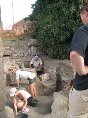
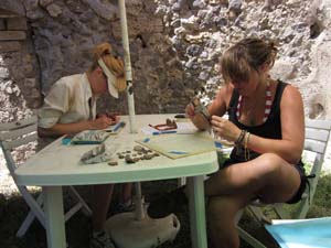
Excavation and Processing underway in AA001 in 2011. |
Field Season 2011 Between the 29th of June and the 27th of July 2011, with the kind permission the Ministero per i Beni e le Attività Culturali: Soprintendenza Speciale per i Beni Archeologici di Napoli e Pompei, and with the kind support of Prof.ssa Cinquantaquattro, Dott. Varone and Dott.ssa Stefani, the members of the Via Consolare Project continued ongoing research into the urban development of Insula VII 6, the area of the Villa delle Colonne a mosaico, and the properties along the route of the Via Consolare. The goals of this summer’s field season were the following: 1. To complete excavation in the eastern half our trench from 2009 (AA001), located at doorway 26 of Insula VII 6 and to clean important areas in preparation for future excavation. 2. To record, study, and process all pottery and finds recovered from continued excavation in preparation for publication. 3. To check our analysis of the walls sequence of the south-eastern corner of the insula, and to implement a working Geographical Information System (GIS) of these walls. 4. To survey the exterior walls of the Terme del Foro in order to incorporate the study of these walls into our analysis of this area, especially in terms of how these walls might relate to the ‘great cistern’ on the eastern side of Insula VII 6, to begin analysis of the walls of the Terme del Foro to complement our survey work and to test hypotheses generated by our excavations in AA001. 5. To deploy fully our 3D acquisition methods using structure-from-motion scanning in excavation, wall analysis, and all aspects of our research. 6. To continue to assist in efforts directed towards rescuing the data produced by the University of Bradford excavations in Insula VI 1. All of these goals were accomplished during our 2011 field season. Excavation of AA001 has been completed successfully, and the entire available archaeological sequence preserved in this area has been recorded. All artefacts recovered have been processed and detailed analysis of the ceramic material from this year has already begun. The walls systems identified and studied in 2007 and 2010 in the south-eastern quarter of Insula VII 6 have been checked against subsurface discoveries, and a working GIS has been created. Preliminary survey and analysis of the Terme del Foro was carried out and has prove immediately to be useful in the larger discussion of the development of Insula VII 6 and the northern end of the Forum. Throughout all of our research, the use of 3D structure-from-motion scanning using consumer grade digital cameras has revolutionized our approach. As a result of this, all phases of our excavation this year were captured in full-3D, and all walls of the south-eastern corner of the insula have now also been recorded in 3D. |
|
Finalisation of Excavation in AA001
In 2011, the Via Consolare Project continued excavation in the area of Insula VII 6, 26 (1) in order to elucidate the nature of the ancient activity identified in the 2008 and 2009 seasons. The area of the eastern half of AA001, measuring approximately four by six metres, was reopened and backfill from 2009 was removed. The continued excavation of AA001 added 30 Stratigraphic Units (SUs) to the 127 stratigraphic units recovered previously and completed several which had not yet been excavated. Excavation was undertaken to the highest level of modern scientific practice, employing 100% screening of excavated soils and total artefact recovery. Additionally, eight-litre environmental samples were taken from each deposit and reserved to be analysed by our environmental specialists during the 2012 field season. With the completion of excavation in AA001, it is now possible to present a complete preliminary sequence for the front rooms of both property 26 and 27, representative of our current interpretations and prior to the finalisation of the study of the pottery sequence in this area. What has come to light is a complicated sequence of urban development, and long-term use and re-use of the south-eastern corner of the block. Such is perhaps to be expected given the proximity of this area both to the Forum, the potential early urban core of the city ( the so-called ‘altstadt’), and the Terme del Foro. It is clear now that evolving utilisation of these areas frequently involved the widespread removal of soils, meaning that the chronological record of the area, though complete in its parts, sometimes requires the thoughtful combination of numerous and diverse pieces of evidence. Careful and thorough excavation, however, has permitted the reconstruction of the complete sequence. Phase 1 – Early deposits In property 27, the earliest deposits in the area were cut into the natural soils and consisted of a few small pit cuts. Here, the nature and use of these cuts is not yet known as the level from which they were cut no longer survives due to the terracing down of the soil level in a later phase. In property 26, the natural soils did not experience similar early cuts, and were only punctured by much later activities. Directly overlying the natural soils, was a thin, highly fragmentary layer of grey silt, with a highly pocked and uneven top surface that was without finds of any kind. Identifying what caused this layer to develop, and its precise interpretation may require assistance from geological experts. It is possible that it should be equated with the abandonment layer identified within the excavations by Progetto Regio VI, (2) which would be very interesting given the proximity of this area to the so-called ‘altstadt.’(3) Immediately overlying this grey silt, both in property 26 and 27, was an equally enigmatic thick (20+cm) deposit of dark grey to black silty-sand, that was equally devoid of all finds (4). In AA001, it seems to have been placed as a foundation prior to the earliest masonry constructions. However, it is difficult to explain how such a layer would have been of benefit either to the stability of early stone structures or to their builders. Phase 2 – Primary spatial division Wall analysis within the Insula suggests strongly that the earliest spatial division in the block was undertaken in opus africanum construction using blocks of Sarno-stone. No clear trace of this activity was recovered from within either shop 26 or 27, which seems rather to have been free from building activity at this time. While traces of an almost entirely removed wall, running from south to north directly above and cut into the black sand could have been a remnant of this phase, truncation of the overlying sequence and the removal of the wall make it impossible to be certain. For this reason, it has been sequenced within its latest possible context – the creation of the Casa di Secundus Tyrannus Fortunatus (cf. infra). The general absence of structures in this area raises a number of important questions about the early shape of the insula, the possible effects of an ‘altstadt’ circuit wall, and our previous ideas regarding an earlier course of the Via Consolare. These will only be resolved via further excavation, such as in the area cleaned within the Casa di Secundus Tyrannus Fortunatus (VII 6, 28), which implied the presence of intact ancient stratigraphy suggested by our geophysical investigations in 2007. Phase 3 – The Casa di Secundus Tyrannus Fortunatus The earliest masonry building activity documented within properties 26 and 27, involved the creation of the circuit walls of the Casa di Secundus Tyrannus Fortunatus. In property 27, a very significant foundation was placed in a deep trench that was seemingly designed to carry a footing of large Sarno stone blocks. Though it was removed at a later phase, an overlying wall, probably constructed in opus incertum of black lava, once served to seal off the southern side of property 27, clearly defining it as a component of the Casa di Secundus Tyrannus Fortunatus. The floor level at this time would have been significantly higher than in the later phases in order to allow proper connection to the house. The eastern side of property 26 was also defined at this point with a large Sarno stone block atop a similar significant foundation with a Sarno stone opus incertum wall running northwards. At the corner of the central north-south wall separating property 26 and 27, two blocks were still in evidence atop a lower black lava footing, seemingly forming a corner turning the southern wall to the north. A much thinner, but also hard-packed footing, running from south to north under the final phase north-south wall, may suggest the course of a now-missing wall that would have also sealed the Casa on the eastern side. If this is so, then a passage may have once separated the two properties, an opening that perhaps significantly aligns neatly with the spur of a road on the opposite side of the Vico dei Soprastanti. Pottery originating from the foundation padding dates this activity to no earlier than the end of the 1st c. BC. With such a late date associated with the earliest attested structures, it is even more important that the absence of earlier buildings so close to the Forum and the city centre should be investigated more fully. There are no traces whatsoever of any sort of wall running across the southern side of property 26 at this time, suggesting either that a doorway punctured the southern wall of the house in this space, or that the eastern wall of property 26 was actually the western wall of another property, with a small space between it and the Casa di Secundus Tyrannus Fortunatus. Complicating matters are the same traces of a now nearly totally-removed wall running from south to north mentioned above and found underlying and filled by deposits of the following phase. These traces comprised a single, heavily-damaged block of Sarno stone, and a groove cut into the underlying black sand deposit. Interestingly, this aligned neatly with a large block of tufo di Nocera in the northern wall of the front room of property 26, which itself was resting upon a heavily compacted earthen foundation. Should this wall be seen as contemporary with the first phase of the Casa di Secundus Tyrannus Fortunatus, then the space between it an the eastern wall of property 26 is far too small for any sort of street, or even a passageway. This relationship will perhaps become clearer as the pottery recovered this year from this early wall begins to provide dating evidence. |

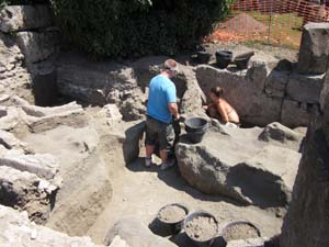
Excavation in 2011. 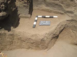
Natural Soils in AA001. 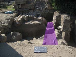
Traces of a missing wall (marked in purple). 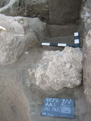
Traces of a missing wall in Sarno stone. |

Black lava incertum build supported by significant wall foundation (photo post removal of foundation). 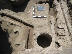
Drainage features in property 26. 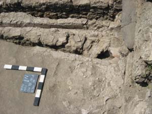
A second drain cutting the first. 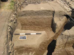
Ancient trenches open at the time of the eruption. 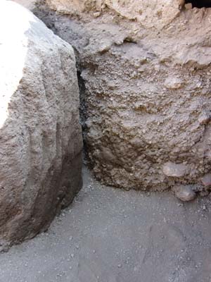
Ancient pick marks visible in the base of one of the trench cuts. 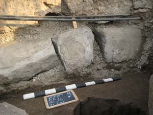
Lava kerbstones collapsed into the sidewalk trench during the eruption - replaced with modern Sarno stones. 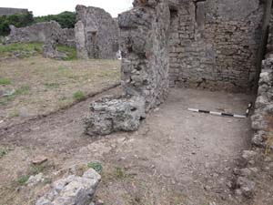
Cleaning in the Casa di Secundus Tyrannus Fortunatus |
Phase 4 – Tufo phase shops
At some point thereafter, probably at roughly the same time as the creation of the Roman colony in 80 BC, both properties 26 and 27 seem to have been reoriented to face south, along with the rest of the south west corner, and converted into shops with frontages created in tufo di Nocera. Perhaps this change was motivated by the new opportunities about to be created by the construction of the Terme del Foro. In order to enable this transformation, the south-eastern corner of the Casa del Tyrannus Secundus Fortunatus was dismantled and the southern wall was removed down to its hard-packed earthen foundations, leaving behind the impression of the Sarno blocks that had once formed the base of the wall. Large blocks of tufo were then levered into place atop the Sarno stone blocks which remained from the original corner. The reorientation of the rooms also required a significant drop in floor level to meet the level of Vico dei Soprastanti. This action clearly caused a compression of the levels of the middle phases between earlier and later activities in the area since the drop in elevation of the area resulted in late features being cut into the earliest deposits. After the frontage had been built, but seemingly before the final shaping of the blocks, a north-south wall was built over a shallow foundation deposit, terminating at a T-junction against the new frontage. If an earlier wall had ever run along this same course, then this new wall was much narrower and less substantial, serving only to separate properties 26 and 27 into separate shops. After its creation, the tufo blocks were shaped to fit the new wall. In property 26, this reshaping left traces of a considerable number of chips of tufo in the deposits which were now used to raise the floor level to be equal with the newly reduced level in property 27. A drain was placed along the western side of this wall in property 27, which seems to have drained water or other fluids from the north to the south and out onto the Vico dei Soprastanti. In property 26, two drains were built, separated by a deep cistern or well with walls that widened slightly as they descended. The first drain, ran at a slight angle against the western side of the cistern/well and thence out onto the street. The second, ran along the eastern side of the same feature, but then turned sharply towards the east where it would have seemingly intersected with the eastern wall. Unfortunately this intersection was not only disturbed by later activity, but also fell outside of the area of AA001, so it is uncertain how this relationship was resolved. It is likely that both shops were provided with packed-earthen floors, which do not survive in the front room of property 27, but were present in property 26. Traces of tile capping on the western of the two drains in property 26, suggest that the top levels of this earthen surface may have not been preserved in AA001, but it is also possible that this capping was intended to sit proud of the floor for ease of maintenance. Phase 5 – Changes to the Shops The shops seem to have existed as created for some time, but throughout the 1st c. AD changes became necessary in both properties. In property 26, the western of the two drains was cut by the creation of a new, more direct drain, which ran parallel to the north-south wall, and emptied onto the Vico dei Soprastanti. At seemingly the same moment, the cistern/well and the L-shaped drain on the east also went out of use and were filled by a shallow levelling layer designed to seal them and to provide a new, higher surface for the new western drain. Given changes also visible in the wall to the north of this room, it seems likely that at least one factor in creating this change was an alteration in the location of the doorway. The earlier drains seem to have been associated with a wide, eastern doorway in the north wall of property 26, while the single drain of the second phase, runs directly under a threshold stone on the western side of a now relocated passage. Further information on the rooms to the north of this space lies under roughly a metre of modern build-up and must await further investigation to be understood fully. In property 27, similar changes were made to the northern end of the front room, probably at roughly the same time. Here a new wall was created in opus incertum of black lava stones, cutting through the drain which had run along the north-south wall, and clearly putting it out of use. This wall was intended to separate property 27 into a front and back room. Certainly this suggests that the process for which the drain had been created was also no longer a consideration for the shop, implying a change in the business undertaken. Phase 6 – Construction work One of the most important aspects of the excavations in properties 26 and 27 was the discovery of large-scale construction work that was underway during the final phases of the city’s occupation. What had been thought to be a collapse in 2008, was proven in 2009 to be large-scale trench work being undertaken during the final moments of the city’s existence. Further components of this phase were uncovered in 2011. Three large, nearly two-metre deep trenches had been cut through the floors of both shops, possibly for the construction of a drainage system that was never completed. Each trench was of such a width that would have accommodated the shoulders of a single man as he dug the trench. Pick marks from the creation of the trenches were still evident in the bases of each, and especially in the natural soils which even preserved the circular swing of the pick as it hit the soil. Additionally, the sidewalk had been excavated along the length of the kerbstones in front of doorways 26 and 27, continuing both to the east and to the west to an as yet unknown extent. The arrangement of these ancient trenches also reveals some potential hints at their purpose. The cuts were arranged as two diagonal trenches, one each in properties 26 and 27. Connecting them was a long trench running in alignment with the Vico dei Soprastanti, and directly under the north-south wall that separated the two properties. The workmen seem to have not bothered with removing the wall, but instead may have supported it with wooden beams fixed together with iron nails which were recovered from this spot. This trench also continued to the east where it was met by a further sloping trench running directly against the easternmost wall in AA001. Plausibly this was intended as an access point, since all of the other trenches were deep and with such straight sides that entering the trench would have been difficult without a ladder. Just before this trench reached the eastern wall, it widened slightly. This was similar to the manner in which it approached the central north-south wall, prior to running directly under the still-standing structure. It is therefore possible that it also ran under the eastern wall and into property 25. The general direction of the trench, combined with its depth, suggests strongly that it was intended to connect to the system of drainage already present on the Vico delle Terme and the Vico dei Soprastanti related to the Terme del Foro and the ‘great cistern.’ Certainly the scale of these activities seems to have been well-beyond that of normal domestic construction, and should be considered as municipal-level undertakings. Phase 7 – Eruption A thin layer of trampled soils mixed with crushed lapilli found at the bottom of the trenches may suggest that the construction work was ongoing during the early stages of the eruption itself, but no other evidence of the workers or their tools was recovered. These trenches then seem to have been filled by the collapse of material that slumped in from the ancient spoil heaps situated to the west and south. The layers were formed from loose spoil similar in colour and texture to the very soils through which the trenches had been cut. Intermixed with these collapses were layers of lapilli and ash from the eruption. At the same time, the kerbstones, which had been severely undercut by the work along them, collapsed into the trench, sealing a layer of lapilli from the earlier parts of the eruption. In the eastern side of property 26, the access trench was filled at its northernmost excavated point by a deposit of very ashy and fine lapilli intermixed with the remains of roof tiles and some fragments of marble revetments from an unidentified source. Early plans (5) of the area show a reconstructed countertop, which, together with the roofing (6) may have been the source of these inclusions. Phase 8 – Modern In the modern period, the area seems to have received only cursory excavation of eruption deposits followed by very limited reconstruction. Some modern mortar implies that a counter may have been reconstructed in property 26. If this is so, then the Allied bombing of 1943 (7) that destroyed many of the standing structures in this area of the insula must also have eradicated this structure. After the bombing, there seems to have been considerable effort directed towards neatening up the insula, and restoring its major features. The northern wall of the east room is now largely a collection of cursorily stacked stones, mostly placed for the purpose of retaining debris from the bombing which has been heaped in the rooms to the north of property 26. Additionally, the tufo plinth atop the ancient tufo base has been re-erected in the modern day after having been toppled in the bombing. Most significantly, large Sarno stone blocks were placed along the street to replace the stones that had collapsed into the trench cut along their north length, plausibly also at this same time. Cleaning in the Casa di Secundus Tyrannus Fortunatus (VII 6, 28) During the final weeks of the field season in 2011, preliminary investigations were undertaken in a 4 by 5 metre area at the north-west corner of the Casa di Secundus Tyrannus Fortunatus (VII 6, 28), in order to establish the degree of preserved stratigraphy below modern build-up, to examine the relationship of the walls below the level of greatest modern exposure, and to compare this information against the geophysical research undertaken in 2007. This area is particularly important as it is situated against one of the earliest walls of the insula which was built in opus africanum of a particularly early type. The clean also uncovered the continuation of a wall which prior to bombing had served to create a small cupboard out of this space, and some section of what must once have been the interior walkway of the peristyle colonnade of the house. On the western side, a deep rubble deposit was encountered that, while probably also of modern origin, was not removed due to the percentage of ancient material contained within it. On the east, no trace was found of cocciopesto surface, but instead a harder packed and finer levelling which might well have been intended as a bedding for such a final-phase surface. |
|
Pottery Analysis, Micro-Faunal Remains, and Numismatics During this season, the Via Consolare Project processed and completed the recording of the ceramic artefact assemblage recovered during the summers of 2008, 2009 including our current excavations in 2011. The team sorted 17.6 kilograms of pottery from all contexts opened this season and finalised Coarse Ware drawings remaining from those contexts examined in 2010. The ceramic material was divided into the classes Impasto, Bucchero, Black Gloss, Red Slip, Thin Walled, Amphora, and Coarse Wares. After all of the pottery was sorted, the diagnostic sherds were drawn and fabric analysis was conducted. Spot dates were also discerned from deposits of interest in the field. A more detailed and definitive study of these contexts during the coming year will produce firm dates for these deposits. Full micro-faunal analysis, including the ongoing study of important carbonized wood remains combined with the continued recovery via floatation from sampled soils will continue in 2012. Nineteen coins were recovered during excavation in 2011, the study of which will add to the information already recovered from those coins found in 2008 and 2009. The large number of low denomination coins recovered from a relatively small area of deposits within the shop at property 26 helps to confirm their identification as working shop floors. Certainly the volume of coins recovered is indicative of some degree of commercial activity in these areas consistent with a pattern already identified by Dr. Hobbs in Insula VI 1. The low value of the coins also suggests that the nature of the business undertaken was likely of a relatively low status. Continuing Walls Analysis in South-east Corner of Insula VII 6 A major goal of this season was to re-examine and begin to finalise our understanding of the standing architecture in the south-east corner of Insula VII 6. This was accomplished with the creation of a fully-functional GIS of the data taken in previous years, especially as they relate to discoveries from excavation in AA001 and the complete block phasing undertaken in 2010. In previous seasons, we performed detailed wall analyses to discern and record the various construction types, materials, and mortar compositions used throughout the insula, focusing on areas of particular relevance to our Archaeological Areas of 2008-2009. Building upon this previously collected data, a comprehensive phasing of the walls was undertaken in 2010 on an insula-wide scale, synthesising a diachronic narrative of the building phases in VII 6. This year, all of these data were combined into a computer based GIS which permitted the checking of data against the standing remains and further refinement of our understanding of the urban transformation of this area. In particular, this has served to highlight the importance of understanding the evolution of the houses, shops and properties of Insula VII 6, in fitting this area of the city into the chronological development of the city as a whole. Certainly important aspects of urban change, such as the evolution of architectural forms defining houses and shops, the transition from residential to commercial spaces, and the probable requisition of private property for the civic activity of water management and distribution are all revealed in the sequence which took place in Insula VII 6. This is especially true because the area is situated so close to the Forum, and clearly participated in changes involving the Terme del Foro, the ‘great cistern’ and the gradual provision of upper stories responding to urban population pressure. Survey and Analysis of the Terme del Foro; Excavation Planning During the field season of 2011, the Via Consolare Project continued to undertake topographic survey with the primary goal of completion of a 3D wire-frame model of Insula VII 6 and the surrounding insulae, especially the Terme del Foro. Beyond this, given the extremely difficult planning conditions in AA001, which was punctuated by very deep trenches and highly uneven surfaces, Total Station Survey also served to replace traditional archaeological planning. A Leica TCR805power Total Station was used in combination with a Leica GMP111-0 Mini Prism to conduct these surveying tasks. All measurements were taken in either Reflectorless Standard or Infrared Fine mode. Every effort was made to maintain a fine level of accuracy (± 1cm) in order to produce a 3D model that will be useful for ongoing research. After re-establishing the grid of known temporary bench mark (TBM) points around Insula VII 6, efforts were focused on extending the model to the east to incorporate the facades and shops of the Terme del Foro, as well as to provide further details within Insula VII 6 itself. This model also serves as the base into which 3D structure-from-motion scanning is coordinated, both to provide accurate scaling for the method, and to coordinate the data into a single 3D model of our research areas. This model will therefore serve to provide a permanent and accurate record of the current condition of all standing remains, subsurface structures, and excavated deposits recovered during present and future excavations. Further, the survey data collected is used by the Project to test and develop theories regarding the use, layout, evolution, and final-phase appearance of our study areas, as well as providing the contact point for coordinating results from our other processes of examination: excavation, wall analysis, and photogrammetry/structure-from-motion. |

Coarse Ware pottery illustrations. 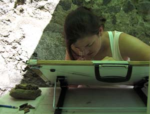
Pottery illustration underway. 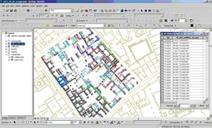
GIS for Insula VII 6. 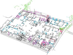
Wire-frame survey model for Insula VII 6. 
Survey south of the Terme del Foro. |
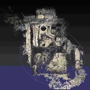
3D point cloud of AA001. 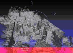
3D mesh surface of AA001. 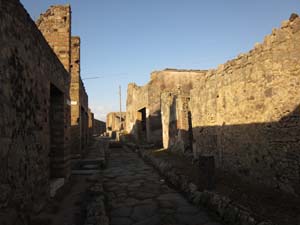
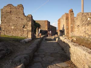
South side of Insula VII 6 |
3D Data Collection
In 2010, the Via Consolare Project was the first archaeological project in Pompeii to initiate use of a recently-released and revolutionary method of 3D data acquisition using structure-from-motion technology (8). Using unordered sets of digital photographs taken with consumer-grade digital cameras, this highly-accurate system produces millions of 3D points of target objects, each with all the point, colour, and surface normal information necessary for complete 3D surface reconstruction. When paired with total station survey of these remains, the end result is a scaled and accurate model of the archaeological remains, down to individual stones. The level of surface detail may be adjusted by means of decreasing the distance between the camera and the subject to be recorded, and hence the system is entirely scalable. This summer, we have utilised this methodology in all aspects of our research, permitting the creation of 3D surface models of walls, streets, kerbing stones, and even excavation deposits. After computer processing, it will therefore be possible to provide a complete 3D model of our excavations in 2011, complete with a precise record of every deposit in situ. The method has also been employed in order to provide information on the faces of each wall in the south-east corner of the Insula, facilitating the creation of a publication-quality computer model of the standing remains in order to illustrate, refine, and test our hypotheses. It is the belief of the VCP that this method will revolutionise modern scientific archaeological methodology, especially in light of our recent successes with implementation. Comparison of our results with recent time-of-flight laser scan data suggests that our results are an equally useful record of the standing remains, permitting a complete 3D reconstruction of the existing walls and floor features. However, unlike current laser-scanning technologies, which require very expensive machinery and access to significant power sources; the method employed by the VCP uses consumer-grade digital cameras. Furthermore, the system is more flexible, since photos may be taken in order to capture data that would otherwise require numerous, time consuming set-ups or otherwise be impossible. As pioneers in this aspect of Pompeian research, we hope that our work will help to advance the standard of research, recording, and analysis undertaken in the city by all archaeological projects. Conclusions Though long-forgotten to scholarly research, Insula VII 6 is of vital importance in the history of Pompeii, and contains a number of clues to the socio-political and economic motivations behind the changing urban environment within the ancient city from its foundation until the eruption of Vesuvius. Our excavations in the southern side of the Insula have yielded significant new information on the motivations and nature of these changes. The work of the Via Consolare Project this summer has permitted us not only to complete the excavation of AA001 and to prepare the materials recovered for publication, but also to check our interpretations of the sequence of the walls in the south-eastern corner of Insula VII 6 and to refine our hypotheses. Cleaning of new areas within the insula has also provided the opportunity to expand our understanding of the block. At the same time this work has posed important new questions that must be investigated in future field seasons through continued walls analysis, cleaning and recording of AD 79 remains and excavation. We plan to return in the summer of 2012 in order to continue excavation in Insula VII 6 and in the area of the Villa delle Colonne a mosaico and to clean, record, conserve, and protect the areas of well-preserved remains that are currently at the greatest risk. Insula VII 6 and the area of the Villa delle Colonne a mosaico have suffered not only due to long exposure and bombing, but also from a scholarly neglect and a belief that little remains to be studied in these areas. Our work has proven conclusively that these areas are not only archaeologically rich, but of vital importance in understanding the development of the city. As always we remain deeply indebted to the Soprintendenza Archeologica di Pompei, Prof.ssa Cinquantaquattro, Dott. Varone and Dott.ssa Stefani, and extend our warmest thanks for their kind and continued support and encouragement in our research activities. |
1. Fiorelli, G. (1875).
2. Coarelli, F. (2008), F. Pesando.(2008). 3. von Gerkan (1940). 4. perhaps similar to that found by Bonghi Jovino in Insula VI 5 cf. Bonghi Jovino, M. (ed.) 1988., and in the Casa degli Epigrammi Greci (VI 1, 18). cf. Staub Gierow, M. (2008). 5. Padiglione, F. (1861), Spano G. (1910), L. Eschebach (1993). 6. The shops probably had upper stories and roofs similar to those reconstructed along the Via Abbondanza. Spinazzola, V. (1953). 7. Garcia y Garcia (2006). 102ff. 8. Ducke, B. (2011). |
|
|
||||||||
|
Website Content © Copyright Via Consolare Project 2018
| ||||||||