
The Via Consolare Project in Pompeii
|
|
||||||||
|
The Via Consolare Project in Pompeii
| ||||||||
| Home | Research | Internships | Team | Links | Contact | |||
| Summary | 2005/2006 | 2007 | 2008 | 2009 | 2010 | 2011 | 2012 | 2013 | 2014 | 2015 | 2016 | 2017 | 2018 | VCP 3D |
| 2019 |
 Excavation in Insula VII.6.
|
Field Season 2008 From the 29th of June through the 10th of August, 2008, with the kind and continued permission of professore Guzzo and dottore D'Ambrosio, and generous cooperation of both the Soprintendenza archeologica di Pompeii and the Direzione of the site, the Via Consolare Project continued archaeological investigations in the area of insula VII.6, the area of the Villa delle Colonne a mosaico and the length of the via Consolare. The team excavated one test trench within Insula VII 6 and cleared modern rubbish and debris from several other critical areas within the insula in order to access the state of preservation of areas long forgotten to Pompeian studies and to record and preserved what remained intact beneath considerable modern accretions. The Project also continued the activities of the 2007 field season, including area-wide wall analysis, recording, and photography, as well as the 3D survey of both areas and the via Consolare itself. Overall the activities of the Project were a complete success and have yielded exciting results whilst also directing the research of the Project into new and interesting avenues for next season. |
|
Excavation in Insula VII 6
In the 2008 season, the Via Consolare Project initiated subsurface excavation, opening a small test trench at doorways 26 and 27 of Insula VII 6 designated as VCP Archaeological Area 1 (AA1). The choice of this area rested upon two features that had become clear in the investigations of the previous year: an anomaly identified in the 2007 geophysical analysis that crossed the sidewalk of this area and photographs uncovered revealing that that this region of the city had suffered especially severe damage during the WWII bombing campaign of 1943. We sought specifically to uncover further information on the anomaly and to determine whether and to what degree the stratigraphy in the area had survived the bombing - important knowledge that serves to inform plans for continued excavation in the future. The Archaeological Area was excavated following a strict methodology of 100% artefact recovery and an eight-litre environmental sample flotation per stratified deposit. Happily, it became apparent immediately that the ancient stratigraphy of the area had been largely unaffected by bombing or later modern disturbance. Excavation revealed that the area had seen considerable activity in both ancient and modern times. One of the earliest deposits uncovered in the area was a deposit of fine, brown silt from which a large pit seems to have been cut. Excitingly, the base of the pit still preserved the marks of the individual shovel strikes made when it was originally cut. Two drains were uncovered in the later levels of the trench, both of which ran north/south toward the vico dei Soprastanti on the south side of the insula and out from the centre of the shops that were situated in this area during the final phase. Significantly, the western drain was not used during this last phase because it was cut off by a block of stone at its south end, putting it out of use. This drain ran along the western side of traces of a sarno stone wall faced in opus incertum, likely a property division at some point of the area's history, and probably one of the major victims of bombing in 1943. The western drain likely went out of use when the properties were combined to the layout that most plans show as the state of the final phase of the area. The eastern drain, however, is likely to have been in use during the final phase of the area, since it aligns neatly with an opening between the street pavement stones that opens directly onto the street surface. While it is not yet known precisely what fluid was being conducted out to the street by these drains, a likely functional explanation is that they were overflow drains from water collection facilities, used also to flush certain materials that derived from the shops themselves. Notably, we uncovered two articulated sections of ceramic pipe that had fed down into the main channel of the drain. A sample of the fill of the pipe was extracted, showing a high volume of charcoal, fish scale, and small bones - likely to have been the contents of the drain during its use in the final phase. These contents may allow us to determine how the property was used in the last days of Pompeii. Many of the deposits in the trench suffered from a high degree of subsidence such that most sloped downward within approximately one fourth of our excavated area. It is likely that this is the result of a collapsed feature that was once underneath these deposits. The centre of the presumed collapse falls just to the north-east of the trench and must have originally been a large void. Due to the fact that the overlying deposits have lapilli between each of the layers of deposition, it is hypothesized that the area collapsed in stages during the eruption of AD 79, with a lower layer falling in first, allowing lapilli to flow into the gap before another layer collapsed, creating many lapilli-defined deposits. More excavation in this area is necessary to determine the nature of the collapse, the source of the two drains, and to gather further information about the use of this property and how it changed over time. Extending the edges of this area to include a wider scope will help us to answer some of these questions. Cleaning in Insula VII 6 The VCP was also given permission to clean several areas of VII 6 to determine the state of preservation of the AD 79 deposits in those areas. Cleaning means that modern accumulation may be removed to expose only the upper surface of what remained when it was first excavated in 1902. Two of the areas we cleaned were found to have a great deal of modern build-up and were therefore left for further investigation in the coming years. The third area cleaned was located along the southern peristyle wall in VII 6, 30, designated as Archaeological Area 2 (AA2). We chose this area for cleaning in order to determine the extent of degradation of a floor that the 2007 geophysical analysis indicated was present across the area, to record any extant architectural relationships and to assess the possibilities for future excavation in order to clarify further geophysical anomolies apparent at depth. To carry this out, we removed the modern deposit covering the area down to the AD 79 level, exposing a highly degraded cocciopesto floor and an intact Nocera tufo drain. It was clear that the underlying final phase cocciopesto flooring had degraded considerably since its original excavation. Along the northern extent of the area we cleaned were the remnants of a low peristyle garden wall, which had once been covered with waterproof plaster. Towards the western extent of the AA, the cocciopesto lips over the base of a mortar stair (SU 5) built on the north face of a threshold stone that led to a second level staircase. The western edge of this mortar step overlies an earlier and better-preserved cocciopesto floor containing marble chips. Whilst the precise dating and sequence of these periods of construction and change within Insula VII 6, 30 must await excavation, nevertheless these stratigraphic details confirm the sequence of development for the peristyle of this house as documented through analysis of the standing remains in 2007. We suggest that though late in overall structure, the Casa di Petutius Quintio was built over at least two earlier and diverse types of structure, perhaps corresponding to the original layout of the Insula. |

Extent of the area of the 2008 test trench. 
Bottom of a pit showing the marks of ancient shovel strikes. 
Length of the eastern drain that may have been in use in AD 79. 
Extent of the area cleaned in VII 6, 30. |

Walls analysis in action. 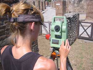
Surveying an area of insula VII 6. 
Total Station survey point cloud of the two research areas connected by the via Consolare. |
Stratigraphic Walls Analysis of the Villa delle Colonne a Mosaico, North and South Shops
This year we continued and expanded the systematic walls analysis in Insula VII 6 that began in the 2007 season. The North and South shops along the Via dei Sepolcri as well as the Villa delle Colonne a mosaico represented the primary areas of focus during the 2008 season. The primary objective in analyzing these structures was to investigate their physical relationships in order to gain a thorough understanding of the building phases and to examine the changing use of space outside the Porta Ercolano during the last several centuries of the life of the city. The results of the wall analysis of these areas revealed a fairly clear and consistent construction process throughout the entire shop area. The initial phase of building consisted of black lava opus incertum walls followed by a second phase of construction, wherein a red cruma opus incertum barrel vault, running north-south, was added in the rear of each property in order to support a second storey. These barrel vaults represent a later addition, as suggested by the light and often inconsistent keying of the barrel vaults into the property walls as well as the construction of small abutment walls, built against earlier plaster layers, which were added in order to bear the weight of the barrel vault in each property. These vaults appear to have supported a second, and possibly even a third storey, as indicated by the extant remains of a second and higher barrel vault in the northernmost shop. Insights into the structural progression of the shops, the Villa delle Colonne a mosaico, and their physical interface and relationship provide the beginning of a thorough understanding of the use of space outside the Porta Ercolano. In the following seasons we will combine these conclusions with 3D survey, rectified photography and future targeted excavation in order to continue to examine the major building phases, physical relationships, and interactions between the shops and the Villa. Future wall analysis will focus on the relative dating of the phases of the Villa delle Colonne a mosaico, the implications of multistoreyed shops, and the physical relationships among the street shops, Villa and the Via Consolare. Decoration Analysis The entrance hallway in the Villa delle Colonne a mosaico features some of the best-preserved and extensive wall painting within our research areas, comprising two sections of surviving plaster stretching nearly half the extent of the hall. In the 2008 season, we examined and documented these walls using several methods: digital photography and rectification; analysis of the wall construction of the northernmost of the two walls; topographical survey; and sketches of the surviving walls, including both elevations and details of each. It is hoped that comparative study within Pompeii and the entire Vesuvian region will allow for the reconstruction of now missing details and the precise dating of this decoration. Total Station Survey This season saw continued production of an accurate 3D record of the standing remains within our study areas. Specifically, we completed the 3D model of Insula VII.6 that was initiated last year, began the above-ground survey of the Villa delle Colonne a Mosaico and joined the two areas of our study together by surveying a base plan along the length of the Via Consolare. In parallel to this work, several new team members were instructed in the theory and method of 3D topographic survey. These data will eventually be used to create a solid and textured 3D model in combination with the rectified walls photography. In addition to surveying the standing remains, large debris and current ground level, we also recorded the baselines and extents of both the test trench (AA1) and the cleaning area (AA2). This was done so that when the drawings are digitised, they can be accurately placed within a completed version of the model as an additional layer of information which can be seen together with the standing remains. We intend the data collected to function in many different ways beyond our initial aim of forming a permanent and accurate record of the current preservation of the remains. In the future it will also be used to demonstrate and test the theories that we develop regarding the appearance, layout, usage, and evolution of the areas we are studying. More importantly, it will be combined with all the information produced from the excavation, wall analysis, rectified photography, and the geophysical survey, forming an easily accessible GIS (Geographical Information Systems) database that will allow other archaeologists to use and reassess all of the data we collect to further their own studies of Pompeii and the wider Roman world. |
|
Conclusions
Our work of this year has provided tantalising clues into the understanding of the Via Consolare, but has also raised a number of important new questions and has guided our research in preparation for next year's field season. Even after several seasons of examination, recording, cleaning and excavation our interpretations continue to evolve and change in the face of exciting new data. Next year we will return in order to investigate these questions and to reopen this year's test trench. We also hope to continue cleaning activities, 3D survey and wall analysis and to expand our subsurface investigations in order to provide greater resolution and precise dating to our phasing sequences. As always we remain deeply indebted to the Soprintendenza Archeologica di Pompei, the Direzione, and especially to Professore Guzzo and Dottore D'Ambrosio and thank them for their kind and continued support and encouragement in our research activities. |
 The 2008 team pausing for a moment during backfill.
|
|
|
||||||||
|
Website Content © Copyright Via Consolare Project 2018
| ||||||||